REVIEW · OAHU
60 Minutes SHARED Helicopter Tour in Honolulu
Book on Viator →Operated by Honolulu Helicopter Tours · Bookable on Viator
Oahu looks different from 1,000 feet. This 60-minute shared helicopter ride traces iconic coastlines and landmarks in a way road time can’t. I like how it strings together views of Waikiki, Diamond Head, Hanauma Bay, and the Pearl Harbor area into one smooth flight.
What really sells it, though, is the human touch. Pilots such as Stefan and Jim are known for calm, just-right commentary and a strong focus on safety. One consideration: this tour needs good weather, so you may have to reschedule if conditions don’t cooperate.
In This Review
- Key highlights worth booking
- Why a 60-minute shared flight works for Oahu’s best views
- Meeting at 1 Lagoon Dr: what to do before you fly
- The Oahu circuit: Waikiki, Diamond Head, and the city-coast mix
- Diamond Head to Hanauma Bay: how the coast changes character
- Makapuu Point Tide Pools and the windward show: Pele’s chair and more
- Pearl Harbor from the air: USS Arizona and the surrounding warships
- North Shore and the country side: Turtle Bay to Haleiwa
- Dole Plantation and the closing loop back to HNL
- Price and value: is $449 per person worth it?
- Weather, weight limit, and schedule reality checks
- Who should book this Honolulu Helicopter Tours flight
- Should you book the 60 Minutes Shared Helicopter Tour?
- FAQ
- How long is the 60 Minutes SHARED Helicopter Tour?
- Where do I meet for the tour?
- Is this a private or shared helicopter tour?
- What language is the tour offered in?
- What is the weight limit per passenger?
- Do I need to buy admission tickets for the stops?
- What happens if weather is poor?
- Can I cancel and get a full refund?
Key highlights worth booking

- Small-group shared flight with a maximum of 3 people, even at shared pricing
- A big island route in 60 minutes, hitting Waikiki, Diamond Head, Hanauma Bay, Makapuu, and Pearl Harbor area sights
- Pilot narration that doesn’t drown out the view, with names like Stefan and Jim showing up in feedback
- Photo-friendly support, including a cell phone lanyard so you can keep your phone ready
- Route includes landmark contrasts, from beach parks to golf-course shoreline to military sites
Why a 60-minute shared flight works for Oahu’s best views

If you have limited time on Oahu, a helicopter tour can feel like cheating—in the best way. You’re not trying to drive from one viewpoint to the next. Instead, you’re getting a single moving panorama, with the island’s shapes doing most of the explaining.
This one is built around a tight schedule: about one hour in the air, starting and ending at Honolulu (HNL). It’s also a shared format, but with a surprisingly small cap—up to 3 passengers. That matters because the experience feels less like a cattle call and more like sharing a big window seat in the sky.
And the timing is clear: you’re seeing Oahu in the same session, covering famous shorelines and famous history without splitting your day into multiple tours.
You can also read our reviews of more tours and experiences in Oahu


Meeting at 1 Lagoon Dr: what to do before you fly

The tour meets at 1 Lagoon Dr, Honolulu, HI 96819, and ends back at the same spot. That’s handy. No long “get back to the airport” scramble.
You’ll use a mobile ticket, so have your phone ready (and charged). If you’re the type who constantly checks where to go, the cell phone lanyard is a small but smart touch—use it so you’re not hunting for a grip when a photo moment pops up.
One practical note from the real-world experience of flying: start times must match what your confirmation says. There was at least one unhappy situation where a time shift showed up in an app, and the group arrived after the actual departure window. The lesson is simple: check the start time again the day of, and plan to be early.
The Oahu circuit: Waikiki, Diamond Head, and the city-coast mix

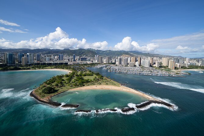
The route begins in the Honolulu area and moves fast into recognizable scenery. You’ll get an aerial sweep over places like Honolulu Harbor, Sand Island, and Ala Moana Beach Park—the kind of coastline that looks busy from the road but reads as a clear pattern from above.
From there, the flight lines up with the parts of Honolulu that most people visit on foot. Waikiki and Diamond Head are major targets, and this is one of the few ways to see how the neighborhood sits between ocean and hills rather than just as a hotel strip.
A nice bonus here is the mix of “pretty” and “structure.” You may also see shoreline-adjacent landmarks such as Magic Island, Ala Wai Harbor, and even the golf-course coastline (Ala Wai and Waialae are named). From the air, those fairways look like green patches stitched into the urban grid—an odd contrast you just don’t get from sidewalks.
As the helicopter moves inland, you also get a change of mood. Punch Bowl Cemetery is one of the named stops on the route, and flying over it helps you understand the scale of the crater-like setting and where it sits relative to the city.
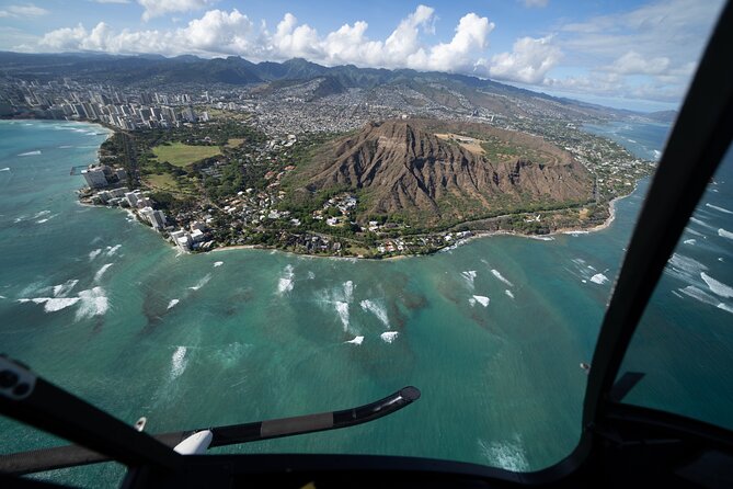
Diamond Head to Hanauma Bay: how the coast changes character

After the Honolulu core, the tour’s view focus shifts toward the island’s dramatic natural edges. Diamond Head is listed as its own highlight, and it’s worth knowing why: it’s one of those landmarks that can look smaller from ground level than it really is. From above, the volcanic shape and the way the ridge runs along the coast become much clearer.
Then comes Hanauma Bay Nature Preserve. Seeing Hanauma Bay from the air gives you the bowl-like look and the pattern of the shoreline that you usually only appreciate after you’ve already done the hike or watched it from a viewpoint. The shape of the bay is the point here.
You also get route coverage that includes a famous windward splash—a blowhole is specifically named. If you’ve ever seen photos of this coast, you know how much the ocean varies over short distances. From the helicopter windows, you’re not guessing. The coastline tells you where energy concentrates and where it calms down.
Makapuu Point Tide Pools and the windward show: Pele’s chair and more

The flight continues to the east side, where Oahu turns from “vacation postcard” into “geology homework.” Makapu’u Point Tide Pools is one of the listed stops, and the aerial view is exactly what you want for tide-pool areas: you can see the way the shoreline shelves and how rock and water interact.
From there, the route includes a string of named coastal and landmark features that make the island feel like one connected scene. Makapuu Lighthouse, Rabbit Island, Pele’s chair, and OloMana are all included as aerial sights. That’s a lot of place names, but in a helicopter those names don’t feel like trivia. They act like coordinates for the changing coastline.
You’ll also likely see Pali Lookout from the air as the route works its way along the ridgelines and valleys. And around the bay-and-coast area, Chinaman’s Hat is included, along with Kaneohe Bay and Marine Corps Base Hawaii.
One of the cool ways to think about this part: it’s where the island’s “layers” show. Ocean in front, ridges and valleys in the middle, and settlements spread out where the land allows it.
You can also read our reviews of more tours and experiences in Oahu


Pearl Harbor from the air: USS Arizona and the surrounding warships
If there’s one moment that feels heavy in a surprisingly visual way, it’s the USS Arizona Memorial area. The tour includes Pearl Harbor Memorial, plus named ships like the USS Missouri (and the listing of the “Mighty Mo” warship) and a retired fleet.
From the air, this part of Oahu reads like a map of decisions made long ago. You can see how the harbor is organized and how the coastline frames the memorial area. That framing matters because ground views can hide the scale. From above, it becomes easier to understand why this location has such a lasting footprint.
The route also calls out additional named sites in the Pearl Harbor zone, including USS Utah. Even if you’re not doing a full museum day, flying past these landmarks gives you a fast “big picture” view that’s hard to replicate.
North Shore and the country side: Turtle Bay to Haleiwa
The tour’s next act leans north, and it’s where the scenery shifts again. You may see Turtle Bay, Sunset Beach, Waimea Bay, and Bonsai Pipeline. These names are famous for waves—and from above you can appreciate how the shoreline and reef shape the surf zones.
You also get a look at Haleiwa Town, along with Oahu Central Valley. That combination helps you see Oahu as more than beaches. It’s a working mix of neighborhoods, agriculture, and open land.
This is also where you’ll spot how wide the island really feels. The ocean isn’t just background; it’s a boundary. And the helicopter view makes that boundary obvious—especially when you watch the coast gradually change from resort strip to rugged shoreline.
Dole Plantation and the closing loop back to HNL

Dole Plantation is one of the listed stops, and the route also notes Dole Pineapple Plantation and the Dole Maze. Even from the air, you’ll understand why that area is a draw: it’s a big, identifiable patch in the middle of the island’s scenery.
Then the flight comes full circle back toward the Honolulu area and your return to HNL and the meeting point.
A key thing to understand about a one-hour helicopter tour: you’re not getting time to wander around each attraction. What you’re getting is a fast visual connection between them. Admission is listed as free for the named stops, but the main value is the aerial perspective—seeing how everything lines up.
Price and value: is $449 per person worth it?
At $449 per person, this isn’t a casual add-on. The value only makes sense if you buy into the core idea: replacing hours of traffic and stop-and-go viewing with a single flight.
Here’s where the math works in your favor:
- Small-group shared format (max 3 people) means less crowding than many “shared” products.
- Admission tickets are listed as free for the named sights, so you’re not paying extra entry fees just to match the route.
- One hour is long enough to see multiple distinct regions of the island, not just one neighborhood and a loop.
It’s also the kind of activity that fits special moments. One review described it as a memorable way to celebrate a husband’s birthday, and the vibe fits: you’re not hunting reservations or squeezing into crowded lanes. You’re getting a shared wow-factor view.
Weather, weight limit, and schedule reality checks
This tour requires good weather. If it’s canceled due to poor conditions, you’ll be offered a different date or a full refund. It’s also a good idea to keep your day flexible around the flight, because that’s the real variable in Hawaii.
There’s also a clear weight limit of 300 lbs per passenger. If you’re near that number, it’s worth checking details before committing.
Finally, pay attention to start time. The short, sharp lesson from a bad experience case is: don’t assume the time in your mind is the time that matters. Use your confirmation, re-check the schedule the day of, and arrive early.
Who should book this Honolulu Helicopter Tours flight
This works especially well if:
- you want big-name Oahu highlights without a full day of driving
- you’re celebrating something and want a shared, memorable moment
- you like the idea of seeing both city and nature in one shot
It may be less appealing if you need long stop times at specific attractions. This is an aerial sightseeing format, so the real payoff is what you see from the air during the hour.
Should you book the 60 Minutes Shared Helicopter Tour?
I’d book it if your priorities are clear: you want Oahu’s famous parts—Waikiki, Diamond Head, Hanauma Bay, Makapu’u, and Pearl Harbor—and you’d rather trade traffic for a single guided perspective. The small-group cap (up to 3 people) and the reputation for pilots like Stefan and Jim make it easier to trust.
Hold off if you can’t risk a weather-related change, or if your schedule is too tight to flex. Also, double-check you’re matching the confirmed start time in your booking app or confirmation, because missing the window can be costly.
If you do decide to go, pack your patience with the island’s mood and keep your phone ready. In an hour, Oahu looks like a connected story instead of a list of stops.
FAQ
How long is the 60 Minutes SHARED Helicopter Tour?
The flight lasts about 1 hour (approx.).
Where do I meet for the tour?
The meeting point is 1 Lagoon Dr, Honolulu, HI 96819, USA, and the tour ends back at the same location.
Is this a private or shared helicopter tour?
It’s a shared tour, with a maximum of 3 travelers.
What language is the tour offered in?
The experience is offered in English.
What is the weight limit per passenger?
The total weight per passenger limit is 300 lbs.
Do I need to buy admission tickets for the stops?
Admission is listed as free for the named sights on the route.
What happens if weather is poor?
The tour requires good weather. If it’s canceled due to poor weather, you’ll be offered a different date or a full refund.
Can I cancel and get a full refund?
Yes. You can cancel up to 24 hours in advance for a full refund.