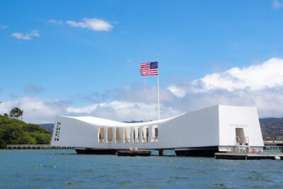
REVIEW · OAHU
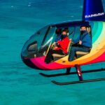
30 Minutes SHARED Helicopter Tour in Honolulu
Book on Viator →Operated by Honolulu Helicopter Tours · Bookable on Viator
Thirty minutes, and Oahu feels new. This shared helicopter tour from HNL gives you big aerial views fast, with a maximum of three passengers so the flight feels personal instead of packed. I like how the pilot’s talk helps you make sense of what you’re looking at—Waikiki, Diamond Head, harbors, and the coast are easier to understand when someone points out the why.
One consideration: at $319 for about 30 minutes, this is a splurge, and the shared format means you’re optimizing for the best route and views—not extra time in the air or complete control over every angle.
In This Review
- Key Things to Know Before You Fly
- Where the Flight Starts: HNL and the First Minutes in the Air
- Waikiki, Diamond Head, and the Coastline You Can’t Recreate from the Ground
- Harbors and Beach Parks: Sand Island, Ala Moana, Magic Island, and Ala Wai
- Downtown Honolulu and Punchbowl Crater: Major Landmarks in One Quick Pass
- Highway Views: H-1, H-3, Interchanges, and Aloha Stadium
- Moanalua Gardens, Black Point Sea Pools, and the End-of-Flight Details
- Price and Value: Is $319 Worth 30 Minutes Over Oahu?
- What’s Included (and What You Should Ask For)
- Who This Helicopter Tour Fits Best
- The Booking Check: Weather, Weight, and Timing Reality
- Should You Book This Honolulu Helicopter Flight?
- FAQ
- How long is the shared helicopter tour?
- What does the tour cost?
- How many people are on the helicopter?
- Where do I meet and where does the tour end?
- What’s included in the tour?
- What landmarks and areas does the flight cover?
- Is the tour dependent on weather?
- What is the cancellation policy?
Key Things to Know Before You Fly
- Small group (max three travelers) helps you feel like you’re watching the island with an attentive crew.
- Pilot commentary turns a quick hop into real orientation: harbors, volcanic landmarks, and neighborhoods make more sense.
- Photo-friendly route covers Waikiki, Diamond Head, the harbor areas, and shoreline spots you can’t reach on a normal drive.
- Headsets included so you can hear the pilot clearly.
- Good weather matters because flight plans depend on conditions.
Where the Flight Starts: HNL and the First Minutes in the Air

You’ll meet at 1 Lagoon Dr, Honolulu, HI 96819, and the tour starts and ends back at that same point. The flight itself begins from HNL, so even before you’re overhead, you get the sense this is built for quick access rather than a long day of waiting.
Once you’re airborne, you don’t ease into the views—you get them immediately. From this height, Oahu’s shape becomes obvious: the ocean wraps around, the coastline changes texture, and the built-up areas show clear boundaries. It’s a fast way to get your bearings for the rest of your trip.
There’s also a practical upside to the 30-minute length. If you’re short on time, this is one of the easier ways to add a helicopter segment without sacrificing an entire morning or afternoon.
You can also read our reviews of more tours and experiences in Oahu


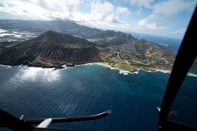
Waikiki, Diamond Head, and the Coastline You Can’t Recreate from the Ground
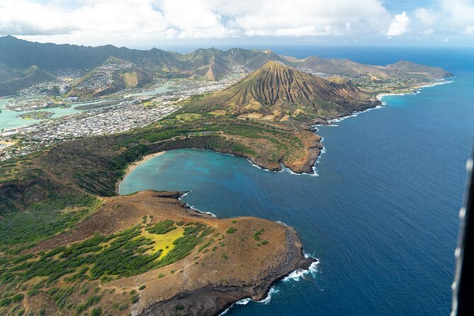
The route is designed to hit the visual hits early: you’ll pass over Waikiki, then Diamond Head (Lēʻahi). Seeing Waikiki from above is different from looking at it from the beach or from a hotel tower. You understand why the neighborhood is shaped the way it is—curving shoreline, beach access, and the way the developed strip sits against open water.
Diamond Head is the kind of landmark that looks cool from the ground, but it’s even better from the air because you can read the volcanic form. The pilot’s commentary adds context, so you’re not just staring at a hill—you’re recognizing it as a volcanic tuff cone and a major visual reference point for the island.
If you like photos, this is your main stretch. Aerial views of beaches and coastline tend to come with cleaner lines and better light angles than many street-level photo spots. Expect a lot of chances to frame the shoreline and the ridgeline with Waikiki in the same shot.
Harbors and Beach Parks: Sand Island, Ala Moana, Magic Island, and Ala Wai

After you leave the core Waikiki/Diamond Head area, the flight shifts toward water and shoreline detail. You’ll see Sand Island and Honolulu Harbor, which is also referred to as the Port of Honolulu. From above, harbors stop being abstract and start looking like living systems—piers, channels, and how the water traffic sits against the city.
Next up is Ala Moana Beach Park, between Waikiki and downtown. From the air, it’s easy to spot the long, gold-sand stretch—plus the park’s position as a connector between busy areas. The size matters here: a 100-acre park isn’t just a “beach stop,” it’s a major public space with clear shape and spacing.
Then you’ll fly over Magic Island (near Ala Moana Beach Park). It’s a small man-made peninsula, and from above you can see the geometry of what was created and how it relates to nearby harbors. After that, you’ll look at Ala Wai Harbor, which sits between Waikiki and Honolulu’s waterfront side.
This segment is for people who enjoy structure and contrast in a photo. You’ll get open water next to marinas, and you’ll see the city’s edge line clearly. It’s also a nice reminder that Oahu isn’t only beaches—there’s a working maritime side that’s right in town.
Downtown Honolulu and Punchbowl Crater: Major Landmarks in One Quick Pass
The tour also loops past Honolulu Downtown, where the city’s political and business center shows up as clusters of buildings. You’ll see Iolani Palace mentioned as a key landmark area, and you’ll also get views toward Aloha Tower Marketplace on the harbor side. From the air, Aloha Tower reads differently than it does at ground level because you can see how it anchors the waterfront.
A standout moment is the approach toward The National Memorial Cemetery of the Pacific at Punchbowl Crater. This isn’t just another tourist stop—it’s a powerful place, and seeing the crater shape from above helps you understand the geography of the memorial setting. Even with a short time overhead, the scale and positioning make an impression.
If you’re the type who likes to connect famous names to real geography, this is a good payoff. You go from “I’ve heard of it” to “I understand where it sits on the island” fast.
Highway Views: H-1, H-3, Interchanges, and Aloha Stadium
One reason this tour works is that it doesn’t only stay in beach-and-trophy-land. You’ll also see Honolulu’s interchange zones, including areas labeled H201 and other freeway connections, then Interstate H-3, also called the John A. Burns Freeway.
What does that mean from a passenger perspective? You get a view of how people actually move around the island. From above, the roads become a map you can read in seconds—straight runs, ramps, and the way the system cuts across terrain.
You’ll also see Moanalua Freeway references (including the section where Route 78 remains designated), plus Aloha Stadium in Halawa. A stadium view might sound like filler, but it’s useful because it shows the inland-to-coast transition and how big infrastructure sits within Oahu’s overall shape.
This is the segment that helps you stop thinking of Oahu as one flat shoreline. It feels more like a complete island with working corridors and neighborhoods beyond the postcard spots.


Moanalua Gardens, Black Point Sea Pools, and the End-of-Flight Details
The later portion includes a mix of green space and coastal features. You’ll fly over Moanalua Gardens, a privately owned public park known for its setting and the Kamehameha V Cottage area. From the air, parks like this read as breathing room—planned land, not random vegetation—and you can see the park’s boundaries against nearby development.
Then you’ll get views toward Black Point Sea Pools. This is a coast-side feature where you can see the rocky shoreline character from above. It’s the kind of spot where a helicopter view makes the scale and layout clearer than a drive-by, because you can see how the ocean meets the land.
The flight wraps back toward HNL, returning you to the meeting point. Because the total time is short, you don’t get worn out waiting for a long stop schedule. It’s simply: look, listen, photograph, repeat.
Price and Value: Is $319 Worth 30 Minutes Over Oahu?
At $319 per person for around 30 minutes in a shared helicopter, this is absolutely a splurge. The value comes from three things that matter on a real vacation:
First, speed. If you want aerial views but you don’t want to dedicate half a day, the time efficiency is hard to beat.
Second, exclusivity of perspective. You’re seeing harbors, Waikiki, Diamond Head, downtown waterfront, and inland freeway corridors from an angle that normal sightseeing can’t replicate.
Third, the pilot experience. The crew includes aviation headsets, and the pilot’s commentary adds meaning—people mention pilots like Scott, Stefan, and Jacob as friendly and thorough. That matters because a short flight needs to feel informative, not just scenic.
If you’re deciding between this and other Oahu activities, think of it like buying orientation and surprise in one ticket. It’s not a cultural museum day; it’s a visual reset of the island’s geography.
What’s Included (and What You Should Ask For)
This tour includes aviation headsets and a cell phone lanyard, which helps if you’re using your phone for quick photos and want to reduce drop risk. You’ll also get a mobile ticket, and the experience is offered in English.
One practical tip: ask about your photo setup on the day. The flight is known for strong photo opportunities, and you can get better results if you know where to aim your camera as the pilot calls out landmarks.
Also, based on past flights, you may want to ask whether doors-off is available for your specific departure conditions. One group specifically mentioned flying with the doors off as a highlight. If it’s an option, it can make the views feel even more dramatic—just remember it’s weather- and aircraft-dependent.
Who This Helicopter Tour Fits Best
This is a great match if you want:
- A fast, high-impact Oahu experience that doesn’t require a full day
- Strong photo opportunities of Waikiki, Diamond Head, and the waterfront
- Small-group comfort, with a cap of three travelers
- A route that mixes beaches, harbors, downtown, and freeway views
It’s also a good choice for families who want a memorable day moment without long walking or long drives. Several flights described the experience as enjoyable for both adults and kids, and the short duration helps keep energy up.
If you’re someone who wants a deep, multi-hour itinerary with lots of time on the ground, you might find this too short. But if your goal is aerial perspective, the 30 minutes are the point.
The Booking Check: Weather, Weight, and Timing Reality
This experience requires good weather. If weather doesn’t cooperate, you’ll be offered a different date or a full refund.
There’s also a 300 lbs total weight per passenger limit listed for the flight. That’s important for planning—make sure everyone in your group fits the number before you fall in love with the idea.
The operator notes confirmation at booking time, and the tour is near public transportation, which can be helpful if you’re not renting a car just for the flight day.
Should You Book This Honolulu Helicopter Flight?
Yes, you should book it if you want a short, high-value way to see Honolulu from above and you’re okay with a splurge price for the time you get in the air. The combination of small group size, pilot narration, and a route that covers Waikiki, Diamond Head, harbors, downtown waterfront, and inland highway views makes this one of the most efficient ways to understand Oahu’s shape.
Skip it if budget is tight, or if you prefer spending time on the ground rather than looking up. For many first-time visitors, though, this flight lands like a highlight because it turns landmarks into geography.
FAQ
How long is the shared helicopter tour?
It’s approximately 30 minutes.
What does the tour cost?
The price is $319.00 per person.
How many people are on the helicopter?
This experience has a maximum of 3 travelers.
Where do I meet and where does the tour end?
The meeting point is 1 Lagoon Dr, Honolulu, HI 96819, USA, and the tour ends back at the same meeting point.
What’s included in the tour?
Included items are aviation headset and a cell phone lanyard.
What landmarks and areas does the flight cover?
You’ll have views of areas such as Sand Island, Honolulu Harbor, Ala Moana Beach Park, Magic Island, Ala Wai Harbor, Waikiki, Diamond Head, Honolulu downtown, Punchbowl Crater, Moanalua Gardens, H-3, and Aloha Stadium, along with additional coastal and neighborhood viewpoints during the route.
Is the tour dependent on weather?
Yes. The experience requires good weather. If it’s canceled due to poor weather, you’ll be offered a different date or a full refund.
What is the cancellation policy?
You can cancel for a full refund up to 24 hours before the experience’s start time. If you cancel less than 24 hours before, the amount you paid won’t be refunded.